


Here I am waving to you, excited that the sun is shining for a second day and that we are about to continue our exploration of the far Eastern Shore. The community of Charlos Cove is on the other side of the cove of the same name (eponymous?).

Seawind Landing Country Inn was the perfect stop on this adventure.
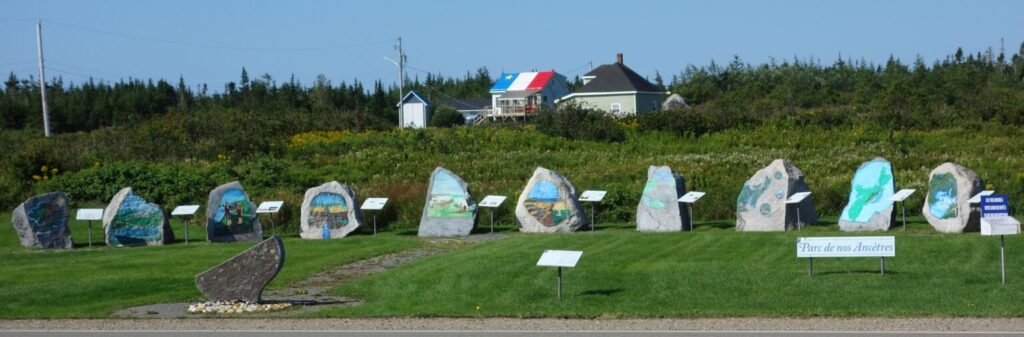
Larry’s River
The next community, Larry’s River, has a powerful expression of Acadian heritage. Parc de Nos Ancêtres is an arc of massive boulders, each with a painting that illustrates the story of Acadians in Nova Scotia. Maybe you’ll get a little verklempt, reading about the decision to live in this far away corner of the province because being invisible felt like the best strategy for survival. More details here.

This is a boulder-rich landscape and I see a reference to the mysterious heritage of standing stones in Europe.
Here is Champlain shaking hands with the hospitable Basque fishing captain Savalette,, who we met in part one.

Another charming feature of the community is a footbridge that connects the two sides of the cove. This convenience enabled children to get to school and parishioners to attend church without a long walk around the cove. The present bridge form dates from the 1940s and has an elevated section to allow fishing vessels to motor under.


The wooden bridge replaced a fear-inducing cable suspension bridge built in 1924, that not surprisingly was known in the community as the “swinging bridge.” It had to be high enough to allow sailing vessels, like the one in the photo, to pass underneath.

Clara Denis, Nova Scotia Archives 1981-541 655
A few years ago the Larry’s River Footbridge Preservation Society was working to preserve the present bridge. It was unclear to me if they had received the support needed for this wonderful symbol and amenity. More details on their site.
Tor Bay
Our stop at Tor Bay was about walking on an empty sand beach in a beautiful provincial park. You know that feeling?

A remarkably beautiful pavilion overlooks the shore, and houses picnic tables and interpretive panels.

Sections of the boardwalk that connects the parking area and the shore were lined with a bountiful crop of cranberries. All looks sort of sublime, don’t you think?

While we were checking out of Seawind Landing that morning I noticed a framed can label from Tor Bay brand blueberries. Seems to be a berry theme here.

The road to Country Harbour
The road zigged down harbours (New, Isaacs, and Country) then zagged through woods and bogs in between. We pulled off to take a closer look at an extraordinary church building in New Harbour. The tower is a four-layer mashup frosted with dramatically failing paint.


The welcome to Goldboro sign says “a community built on gold.” There was gold mining here at the beginning of the last century and more recently this is where Sable gas came ashore and where the pipeline to New England began. For the past few years the location has been proposed as a site for an LNG terminal. We assumed that the offshore supply vessel lingering beside Drum Head had something to do with the going and coming of these projects.

At Tor Bay we learned that the first transatlantic cable came ashore there in 1875. The cable and the LNG proposal remind us that this coast may be far from Halifax but it is close to Europe.
The curvy false front on an abandoned shop in Goldboro was too good to miss. We turned around and went back to get this shot before it was swallowed by vegetation. At the time the curves reminded me of clouds, but now I can imagine some of you scamps will see a poop emoji.

Present day shops along the shore look mostly like this one in Country Harbour Cross Roads. It made me recall a similar business I’d seen on my first visit along this road in 1973.

I forget exactly where Truman M. Giffin’s shop was located but it was somewhere in this area. Imagine a time and world where shops that look like this still made sense in rural Nova Scotia. Could that ever happen again?

We hoped to take the newly free Country Harbour cable ferry but it was not running (we were told someone forgot to order a new cable, but you know how people talk). So we took the inland route to connect to Route 7 and the familiar section of the Eastern Shore. Maybe there is enough material for a Part Three, if we are all up for it.
Postscript
- Soon into our trip we noticed that the Municipality of the District of Guysborough were investing in simple branding elements. Their signage has a distinctive shape, and crisp typography. It appears the Municipality built their own trash and recycling containers that also help identify sites they manage. When we were visiting Tor Bay beach we saw that their Recreation Department had a new electric vehicle that had brought kids to the shore. It all caught our attention and made us realize that design conscious people were at work.

- Photographs taken by Clara Dennis in the Public Archives collection are gold. She travelled all over the province in the 1930s taking pictures and writing stories. Her photos are often not quite in focus or a little crooked, but record so much that would otherwise be missing. When looking for the photo of the Larry’s River footbridge I came upon these delightful shots she took of Acadian kids in Charlos Cove who had been picking foxberries.
In my imagination the first photo is the spirited group when she happened upon them. The second shot is after someone got them organized and quieted down. Also brilliant is the collection of Mi’qmaw-made baskets and the hairstyle of many of the girls.

Clara Denis, Nova Scotia Archives 1981-541 267a

Clara Denis, Nova Scotia Archives 1983-468 117
